Difference between revisions of "Category:Lake Sediments Working Group"
Nick mckay (Talk | contribs) (Particle size) |
Nick mckay (Talk | contribs) (grainsize) |
||
| Line 104: | Line 104: | ||
{| class="wikitable" | {| class="wikitable" | ||
|- | |- | ||
| − | |+Table : Essential/Recommended/Desired Metadata for | + | |+Table : Essential/Recommended/Desired Metadata for particle size properties of sediment |
|- | |- | ||
! Metadata || Essential (E)/ Recommended (R) / Desired (D) || Reason || Added by (optional) | ! Metadata || Essential (E)/ Recommended (R) / Desired (D) || Reason || Added by (optional) | ||
| Line 116: | Line 116: | ||
| Summary statistics used to characterize distribution || R || typically median, mode, skewness, kurtosis, sorting statistics, other quantiles || [[nick mckay]], [[Darrell]] 15 September 2017 | | Summary statistics used to characterize distribution || R || typically median, mode, skewness, kurtosis, sorting statistics, other quantiles || [[nick mckay]], [[Darrell]] 15 September 2017 | ||
|- | |- | ||
| − | | Pretreatment Method || R || methods for removing organic, carbonate and biogenic silica components of sediment, as well as defloculation || [[nick mckay]], [[Darrell]] 15 September 2017 | + | | Particle size type || R || e.g., inferred or measured density|| [[nick mckay]], [[Darrell]] 15 September 2017| Pretreatment Method || R || methods for removing organic, carbonate and biogenic silica components of sediment, as well as defloculation || [[nick mckay]], [[Darrell]] 15 September 2017 |
|- | |- | ||
| − | | Analytical Method || R || e.g, laser diffraction, sieving, pipette settling, sedigraph, counter, hydrometer || [[nick mckay]], [[Darrell]] 15 September 2017 | + | | Analytical Method || R || e.g, laser diffraction, sieving, pipette settling, sedigraph, counter, hydrometer, image analysis|| [[nick mckay]], [[Darrell]] 15 September 2017 |
|- | |- | ||
| Analytical Instrument || R || e.g, Coulter LS 230|| [[nick mckay]], [[Darrell]] 15 September 2017 | | Analytical Instrument || R || e.g, Coulter LS 230|| [[nick mckay]], [[Darrell]] 15 September 2017 | ||
Revision as of 21:47, 15 September 2017
Contents
Overview
In the Linked Earth context, a working group (WG) is a self-organized coalition of knowledgeable experts, whose activities are governed herewith. This page is dedicated to the discussion of data and metadata standards for lake sediments (see this page for a definition of the lake sediment archive), and aims to formulate a set of recommendations for such a standard. Note that chronological aspects should be discussed within the Chronologies WG.
Members of 'Lake Sediments Working Group'
This working group has 15 members.
Specific tasks
Thinking about data standards for lakes is a challenging task because of the incredible diversity of observations made on this archive. To start this process, the working group will focus on developing standards for the one variable in lake sediments that all scientists rely on: depth.
After we've done this process for depth, I suggest we reach out and broaden this group to include broad expertise of different sensor and observations types. A preliminary list is presented below.
Task 1: Depth
How should we report depth?
For this discussion we recommend:
- structuring discussions around what scientific questions one would want to ask of the data
- listing essential, recommended, and desired information for:
- the measurements themselves
- any inference made from the measurements (e.g. calibration to temperature)
- the underlying uncertainties, and what those numbers correspond to (e.g. 1-sigma or 2-sigma?)
- provide an ideal data table for each type of observation, so the community knows what to report and how to report it.
- provide separate recommendations for new and legacy datasets
Sample Depth
Note: Do not edit the polls (even for typos) once voting has started as it will reset the vote counts to zero. If a change needs to be made, make an annotation above the old poll (i.e., above the poll tags) and place the new poll below the first one.
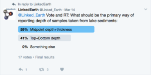
In all cases, most simply, we want to report the geometry of a sample from a core. This requires two pieces of information, typically this is either the mid-point depth and thickness, or top and bottom depth. Each has its advantages:
- Top and bottom depth is more explicit and self explanatory, but typically requires an additional step to use for analysis
- Mid-point depth is more typically reported, and is what is needed for most age models, but can be ambiguous
In the case of tilted or deformed sedimentary units (for instance due to coring operations), core depths should be read at the center of the core, and information regarding the width of the subsample should be reported.
You are not entitled to view results of this poll.
The wiki and twitter polls indicate a slight preference for mid-point and thickness
Dealing with multiple cores
Commonly, multiple cores are used in a study that each have their own depth scale ("Core Depth") and using various methods, those depths are converted to "Composite Depth", which is used for most of the scientific inference. This is important additional information. We want:
- Mid-point depth (Core Depth)
- Mid-point depth (Composite Depth)
- thickness
and ideally, we want to store the necessary information that describes the relationship between core depth and composite depth.
LacCore (and others) use splice and affine tables to accomplish that.
Add a description and discussion of splice and affine tables for discussion here.
Depth Datum
For both core depth and composite depth, we need a datum for depth. Most typically, this is the top of the sediment in each core, for core depth (where depth=0), and is the sediment surface for composite depths. Sometimes, depth from the lake (water) surface is used.
We need to either
- Describe what datum is being used for each depth measurement
OR
- choose a universal datum and force datasets to adhere
Or we could do both.
Sensors
Sensors in lakes fall into several different categories
Physical properties of sediment
Several observations can be made on sedimentary sensors including:
- Density
| Metadata | Essential (E)/ Recommended (R) / Desired (D) | Reason | Added by (optional) |
|---|---|---|---|
| Density | E | e.g., Wet Bulk Density, Dry Bulk Density, gamma attenuation derived density, X-radiographic derived density, CT-scan derived | nick mckay, Darrell 15 September 2017 |
| Water content / Porosity | R | Often measured along with density, in % mass (for WC) & % volume (for porosity) | nick mckay, Darrell 15 September 2017 |
| Native data (for inferred density) | D | measured data used to infer density | nick mckay, Darrell 15 September 2017 |
| Units | E | for all variables. e.g., mass per volume, preferably g cm-3 | nick mckay, Darrell 15 September 2017 |
| Density Type | R | e.g., inferred or measured density | nick mckay, Darrell 15 September 2017 |
| Method | R | e.g, direct sampling, gamma attenuation, X-ray, CT | nick mckay, Darrell 15 September 2017 |
| Interpretation | R | Is the density sensitive to organic content, glacier extent, temperature, geomorphology? | nick mckay, Darrell 15 September 2017 |
- particle size
| Metadata | Essential (E)/ Recommended (R) / Desired (D) | Reason | Added by (optional) | |||
|---|---|---|---|---|---|---|
| % volume or mass (depending on method), by grain size class/interval | E | Should usually sum to 100% across all classes | nick mckay, Darrell 15 September 2017 | |||
| Units | E | for all variables. e.g., usually percent by mass or volume | nick mckay, Darrell 15 September 2017 | |||
| Native data (full range of measured grain sizes) | R | if above is presented at coarser grain size than measured | nick mckay, Darrell 15 September 2017 | |||
| Summary statistics used to characterize distribution | R | typically median, mode, skewness, kurtosis, sorting statistics, other quantiles | nick mckay, Darrell 15 September 2017 | |||
| Particle size type | R | e.g., inferred or measured density | nick mckay, Darrell 15 September 2017| Pretreatment Method | R | methods for removing organic, carbonate and biogenic silica components of sediment, as well as defloculation | nick mckay, Darrell 15 September 2017 |
| Analytical Method | R | e.g, laser diffraction, sieving, pipette settling, sedigraph, counter, hydrometer, image analysis | nick mckay, Darrell 15 September 2017 | |||
| Analytical Instrument | R | e.g, Coulter LS 230 | nick mckay, Darrell 15 September 2017 | |||
| Interpretation | R | Is the percent abundance grain size class interpreted to reflect environmental variability (e.g., lake level, flooding, dust deposition, glacial activity, etc)? | nick mckay, Darrell 15 September 2017 |
- mineralogy
Geochemical properties of sediment
- bulk organic carbon concentrations
- bulk inorganic carbon concentrations
- bulk nitrogen concentrations
- C:N
- isotope geochemistry
- bulk organic carbon isotopic composition
- bulk inorganic carbon isotopic composition
- bulk nitrogen isotopic composition
- Compound Specific Isotopic Analysis (CSIA)
| Metadata | Essential (E)/ Recommended (R) / Desired (D) | Reason | Added by (optional) |
|---|---|---|---|
| Category: Location_(L) (Lat, Lon) | E | Location is a must | Jrichey (talk) 07:40, 24 April 2017 (PDT) |
| Property:Wgs84:Alt (L) (Depth) | E | Water depth can be useful to get an idea of diagenesis in the core. Especially for deep-sea drilling sediments, water depths can be important to assess various biogeochemical properties | Jrichey (talk) 07:40, 24 April 2017 (PDT) |
| Sample Depth | E | Positional information needed to relate the samples back to the archive | Jrichey (talk) 07:40, 24 April 2017 (PDT) |
| ChonDataTable | E for new datasets/ R for legacy datasets | The raw radiocarbon, tie points, 210Pb measurements should be made available so that age models can be updated in light of new calibration curves or new age modeling techniques | Jrichey (talk) 07:40, 24 April 2017 (PDT) |
| Compound(s) analyzed | E | e.g., n-alkanes, FAMEs, alkenones, dinosterol | Jrichey (talk) 07:40, 24 April 2017 (PDT) |
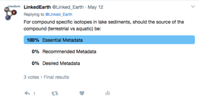
| Source of compound in sediments | R | Is this compound marine/aquatic or terrestrial in origin? | Jrichey (talk) 07:40, 24 April 2017 (PDT) |
| Isotope measured | E | e.g., ∂2H, ∂13C, ∂15N | Jrichey (talk) 07:40, 24 April 2017 (PDT) |
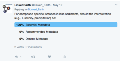
| Environmental Parameter CSIA is sensitive to | R | Is the CSIA sensitive to salinity, precipitation, E-P, productivity, temperature? | Jrichey (talk) 07:40, 24 April 2017 (PDT) |
Note: Do not edit the polls (even for typos) once voting has started as it will reset the vote counts to zero. If a change needs to be made, make an annotation above the old poll (i.e., above the poll tags) and place the new poll below the first one.
You are not entitled to view results of this poll.
You are not entitled to view results of this poll.
You are not entitled to view results of this poll.
Aquatic organisms
Several sensors may be found in lakes including
- Diatoms
- may contribute silicic microfossils and biomarkers
- Ostracods
- may contribute carbonate microfossils
- Algae
- may contribute biomarkers, including alkenones
- Archaea
- may contribute biomarkers, including GDGTs
- Bacteria
- may contribute biomarkers, including GDGTs
- Fish
- may contribute macrofossils, including otoliths
Terrestrial plants
Plants growing around the lake and in the catchment of the lake may contribute macro and microfossils as well as biomarkers to the sediments. Plants are the sensors of the environment and the observations include:
- Organic geochemical biomarkers:
- plant wax n-alkanes
- plant wax n-alkanoic acids
- plant wax n-alkanols acids
- plant wax terpenoids
- lignin
- Macro/microfossils
- pollen
- leaf
- wood
- charcoal
Insects
Several sensors in the air above and around lakes may leave microfossils in lake sediments, these include
- chironimid tests, these are organic microfossils
Magnetic data
From Steve Lund
| Metadata | Essential (E)/ Recommended (R) / Desired (D) | Reason | Added by (optional) |
|---|---|---|---|
| Category: Location_(L) (Lat, Lon) | E | Location is a must | Deborah Khider (talk) 12:05, 14 September 2017 (PDT) |
| Property:Wgs84:Alt (L) (Depth) | E | Deborah Khider (talk) 12:05, 14 September 2017 (PDT) | |
| Position within the lake basin | E | Need to know the distance from land | Deborah Khider (talk) 12:05, 14 September 2017 (PDT) |
| Ancillary data about the archive (carbonate and organic content) | R | Deborah Khider (talk) 12:05, 14 September 2017 (PDT) | |
| Flag that the signal recorded hasn't been altered by geochemistry | D | Deborah Khider (talk) 12:05, 14 September 2017 (PDT) |
Polls
Here are polls that the group might want to consider:
References
This category currently contains no pages or media.


