Category:Floods Working Group
Contents
Overview

In the Linked Earth context, a working group (WG) is a self-organized coalition of knowledgeable experts, whose activities are governed herewith. This page is dedicated to the discussion of data and metadata standards for Inferred Variables of floods, and aims to formulate a set of recommendations for such a standard and a common classification used across all kind of proxy types. It will be closely linked to the hydrology class. This working group is an initiative of the Pages Floods Working Group.
Flood estimations can be derived from various archive types, like
- Lake Sediments
- Fluvial Sediments
- Marine Sediments
- Speleothems
- Trees
- Historical Documents
- ...
so this data standard will also be a special subgroup of the Cross Archive Metadata, standardizing Inferred Variables.
Members of 'Floods Working Group'
This working group contains only the following member.
Flood Parameters
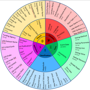
The Pages Flood Working Group started to collect parameters, relevant for analyzing, comparing and disseminating flood data. Most of them already exist (at least similar) in the LiPD definition, but some may need to be added. Following main areas can be distingushed:
Source
The Source cluster refers to the creation of the data. It best corresponds to the Base metadata of LiPD.
| Parameter | Type | Format | LiPD area | LiPD parameter |
|---|---|---|---|---|
| Institution | String | - | aaa | aaa |
| Acquisition Date | String | ISO 8601 | aaa | aaa |
| Proxy Type | String | aaa | Base metadata | archiveType |
| Investigator Name | String | - | Base metadata? | Investigators/contributor |
| Investigator ID | String | - | Base metadata? | Investigators/contributor |
| ID Investigator Standard | String | aaa | Base metadata? | Investigators/contributor |
| Source Year | Int | Gregorian | Historical Documents | not yet defined |
| Source Title | String | - | Historical Documents | not yet defined |
| Source Author | String | - | Historical Documents | not yet defined |
| Source Quote | String | UTF8 | Historical Documents | not yet defined |
| Probe ID | String | - | aaa | aaa |
| Sample ID | String | - | PhysicalSample | HasIGSN |
| Comment | String | - | aaa | aaa |
Location
The Location cluster refers to the location of the data (!). It best corresponds to the Geospatial metadata of LiPD; see also http://schema.org/Place .
| Parameter | Type | Format | LiPD area | LiPD parameter |
|---|---|---|---|---|
| Latitude | Float | WGS-84 | Geospatial metadata | Location |
| Longitude | Float | WGS-84 | Geospatial metadata | Location |
| Resolution | Float | km | Geospatial metadata | aaa |
| Country Name | String | alpha-3 or english short | Geospatial metadata | Location |
| Location Name | String, UTF8 | - | Geospatial metadata | Location |
| Catchment Name | String, UTF8 | - | Geospatial metadata | Location |
| Catchment Area | Float | km^2 | Geospatial metadata | aaa |
| Elevation | Float | m asl | Geospatial metadata | aaa |
| Plain Type | String | - | Geospatial metadata | Location |
| River Name | String, UTF8 | - | Geospatial metadata | Location |
| Lake Name | String, UTF8 | - | Geospatial metadata | Location |
| Lake Surface | Float | km^2 | Geospatial metadata | aaa |
| Max Depth | Float | m | Geospatial metadata | aaa |
Time
The Time cluster refers to the chronology of the data. It best corresponds to the Chronology Tables of LiPD.
| Parameter | Type | Format | LiPD area | LiPD parameter |
|---|---|---|---|---|
| Event Date | String | ISO 8601 | aaa | aaa |
| Uncertainty | Float | days | aaa | aaa |
| Dating Method | String | - | aaa | aaa |
| Dating Parameter | String | - | aaa | aaa |
| Dating Unit | String | - | aaa | aaa |
| Dating Value | Float | - | aaa | aaa |
| Dating Tolerance | Float | - | aaa | aaa |
| Sample Depth | Float | m | aaa | TakenAtDepth |
| Zero Date | String | ISO 8601 | aaa | aaa |
Classification
Reference
This category currently contains no pages or media.
